

Archive Record
Images
Metadata
Accession # |
A2001.100 |
Title |
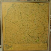
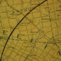
Kitchener - Waterloo Record / Map of / Midwestern Ontario, 1951. |
Date |
1951 CIRCA |
Description |
Kitchener - Waterloo Record map of Midwestern Ontario, Published by the Kitchener-Waterloo Record, Kitchener, Ontario, 1951. Compiled and drawn by W. Russell, Geographer. Lithographed by Merchants Printing Company Limited, Kitchener, Ont. Inset map shows area of map within the Province of Ontario. Legend shows cities, towns, villages, post offices, municipal and watershed boundaries, elevations, railways and stations, lakes, rivers, County Forest tracts, Game Preserves, Distribution area for Kitchener-Waterloo Record. Map has been mounted on masonite and framed. MAP 962. |
Creator \ Maker |
Kitchener-Waterloo Record [Publisher] |
Creator \ Maker |
Russell, W. [CARTOGRAPHER] Merchants Printing Company Limited [Printer] Haines, William [FRAMER] |
Item Name |
Map |
Person \ Organization |
Kitchener-Waterloo Record |
Place |
Wellington County Bruce County Grey County Waterloo County Oxford County Brant County Wentworth County Halton County Peel County Dufferin County Simcoe County |
Subject |
Transportation Post Office Environment Government Property Communications Commercial Railroad Geography |
Photo, Map # |
MAP 962 |
Year Range from |
1951 |
Year Range to |
1951 |
Accession # |
A2001.100 |
Containers |
E916 |