

Archive Record
Images
Additional Images [13]
Metadata
Accession # |
A2017.174 |
Title |
Maps of Wellington County towns and townships, ca. 1820-1974. |
Date |
Circa 1820-1974 |
Description |
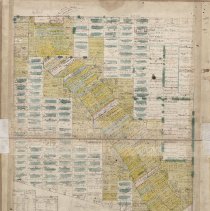
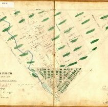
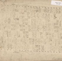
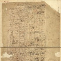
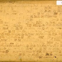
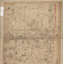
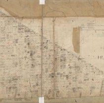
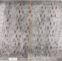
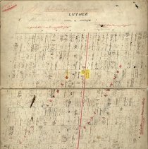
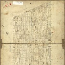
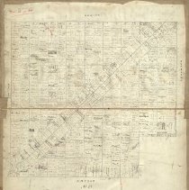
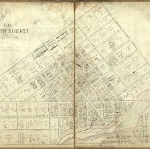
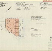
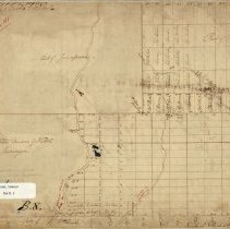
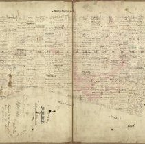
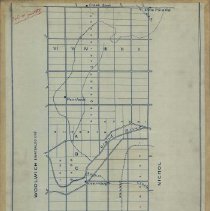
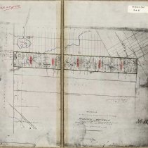
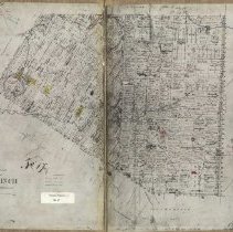
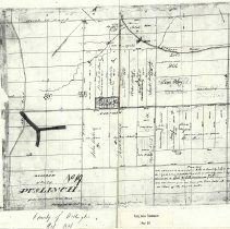
Maps of Wellington County towns and townships, ca. 1820-1974. 19 Digital JPG images, copies made ca. 2015 of maps originally drawn between ca. 1820-1974. Many of the earlier plans are patent maps produced by or for the Department of Crown Lands, indicating who had received what land from the Crown. - MAP 3072: Map of Arthur Township titled "Plan / of the / Township of Arthur / west of Luther and north of the Purchase Line surveyed in 1828", by surveyor, John McDonald, 13 January 1841. Inscribed onto the map at a later date are the names of settlers on each property. Properties have been colour coded, but there is no key to what the colours denote. - MAP 3073: Map of Arthur Village titled "Arthur / with the Park Lots" by surveyor, John McDonald, 1842. It depicts the triangle of the village with street names. Property owners are indicated on each lot. - MAP 3074: Map of Eramosa Township titled "Eramosa District of Gore A.13", ca. 1825. Cartographer unidentified. Inscription at right partially legible, "…24 December 1819". Identifies lots and concessions with property owners' names inscribed over each lot. - MAP 3075: Map of Eramosa Township, Halton County, Gore District, titled "Eramosa / County of Halton / Copied from Ryckman's Survey", ca. 1830. Property owners are identified on each lot. Note at bottom reads, "Lands marked CCL returned / to the Court of Crown Lands / as Forfeited 23rd January 1844." Cartographer unidentified. - MAP 3076: Map of Erin Township titled "Erin, South part, Dist't of Gore", ca. 1830. Cartographer unidentified. Shows Lots 1 through 17 in Concessions 1 through 11. Property owners have been identified on each lot. - MAP 3077: Map of Erin Township titled "Township of Erin / in the County of Halton, District of Gore", ca. 1840. Cartographer unidentified. Notes at bottom, "Surveyed after the new method / Lots marked CCL returned Court / of Cr Lands as forfeited 23rd January 1844". Includes note at top about land granted for the use of S.S. No. 12 Erin Township. Property owners have been identified on each lot. - MAP 3078: Map of Garafraxa Township titled "Township / of / Garafraxa / in the County of Halton / copy from Samuel Ryckman's Survey by J.[B?]O.", ca. 1845. Note at bottom right, "District of Wellington / County of Wellington". At a later date, someone has indicated the place where East Garafraxa Township and West Garafraxa Township were divided. Property owners have been identified on each lot. - MAP 3079: Map of Luther Township titled "Luther", by Lewis Burwell of Brantford, 1831; also dated June 1850[?]. Note at right reads, "County of Simcoe / County of Wellington". Property owners have been identified on each lot. - MAP 3080: Map of Luther Township titled "Luther / in the County of Wellington", dated by the Department of Crown Lands at Quebec, 05 December 1860. Cartographer unidentified. Property owners have been identified on each lot. - MAP 3081: Map of Maryborough Township titled "Maryborough / Wellington County", dated at the Crown Lands Department surveyor's office in Montreal, 25 April 1849. Property owners have been identified on each lot. - MAP 3082: Map of Minto Township titled "Minto / Wellington County", by "C. Rankine[?], 17 Mar. 1853; signed by the Crown Lands Commissioner and dated by the Crown Lands Department office at Quebec, 02 December 1853. Property owners have been identified on each lot. - MAP 3083: Plan of the village of Mount Forest titled "Mount Forest / Office Copy", signed by the Commissioner of Crown Lands at the Crown Lands Department in Quebec, 25 March 1854. Shows street names, lots, and park lots, with property owners identified on each lot. Pencil notation at top, "All in the County of Wellington / by Proclamation 23 Nov. 1865". - MAP 3084: Survey plan of subdivision of Park Lot 1 South of Albert Street in Mount Forest by Alex Wilson, OLS, of Mount Forest, 1974; subject area shaded in pink; approved under section 33 of the planning act on 10 April 1974. - MAP 3085: Map of parts of Nichol Township and Eramosa Township titled "Nichol / District of Gore", cartographer unidentified, ca. 1820. It shows the southern half of Nichol Township on which property owners have been marked. There are only two of them - Roswell Matthews and John Page, both shown with properties around the area where Elora would be founded in 1833. The location of two waterfalls along the Grand River and their depth have been noted. These waterfalls became the sites of the future villages of Elora and Fergus. The northern portion of Eramosa Township is also shown with some property owners. The areas of a "cedar swamp" and a "strawberry marsh" have been indicated along the Nichol-Eramosa townline. Note on empty area north of the Grand River reads, "NorthWestern Division of Nichol / Unsurveyed". - MAP 3086: Map of Peel Township titled "Peel", possibly by Thomas Parker, Surveyor General, 1844. Dated at the Surveyor General's Office in Kingston, 13 January 1844. Returned to the Commissioner of Crown Lands for sale, 23 April 1844. Property owners have been identified on each lot. - MAP 3087: Map of Pilkington Township titled "Township of Pilkington in the County of Wellington", ca. 1965. It shows unidentified roadways, lots and concessions, and the locations of the communities of Alma, Creekbank, Pentland, Inverhaugh, Ponsonby, Weissenburgh and Ariss. Also identified are the Grand River, Swan Creek, Hurst Creek, the Grand Trunk Railway, and the Canadian Pacific Railway. Just south of Ariss is marked the location of "Peterson Sta[tion]". Drawn in red are subdivided properties on Lot 10 and Lot 11, Concession 4, East of the Grand River. Note at bottom of map suggests encourages further research, likely on the properties marked in red. - MAP 3088: Map of the southern part of Puslinch Township and northern part of Beverly Township, ca. 1831, titled "Diagram / of a vacant tract of land lying between the township of / Puslinch and Beverly / containing about 7093 acres exclusive of Roads Surveyed / in the office / (Discovered by David Gibson Dpy Surveyor when on the / Survey of Puslinch in 1831". The reference is to the Gore Concession of Puslinch Township which is shown at centre, with property owners identified on each lot. Also identified is Puslinch Lake, Little Lake, and Galt Creek. A couple of notations have been signed "J.G.C." - MAP 3089: Map of Puslinch Township titled "Diagram of Puslinch", cartographer unknown, ca. 1845. Property owners have been identified on each lot. Also identified is Puslinch Lake, Little Lake, Galt Creek, Fairchild Creek, and the Speed River. Aside from 19th-century inscriptions, some have also been made with a blue ball-point pen, suggesting entries from the late 20th century. Highlighted in yellow are Crown Reserve lands. - MAP 3090: Map of a detail of Puslinch Township titled "Diagram of part of Puslinch", surveyed by Deputy Surveyor, David Gibson, in December 1831. It shows the community of Arkell at Farnham overwritten with name of owner "Thomas Arkell". Neighbouring farm lots and their owners also indicated. |
Creator \ Maker |
Unknown |
Creator \ Maker |
Burwell, Lewis Crown Lands Department Gibson, David McDonald, John Ryckman, Samuel Parker, Thomas Rankin, C. Wilson, Alex R. |
Item Name |
Copy, Digital Map Plan Survey |
Person \ Organization |
Arkell, Thomas Canadian Pacific Railway Crown Lands Department Government of Canada Grand Trunk Railway Mathews, Roswell Matthews Page, John Peterson Station S. S. #12 Erin Twp. |
Place |
Albert Street Alma Ariss Arkell Arthur Arthur Twp. Beverly Twp. Brantford Creekbank East Garafraxa Twp. Elora Eramosa Twp. Eramosa Twp. Erin Twp. Fairchild Creek Farnham Fergus Galt Creek Garafraxa Twp. Gore District Grand River Halton County Hurst Creek Inverhaugh Kingston Little Lake Luther Twp. Maryborough Twp. Minto Twp. Mount Forest Nichol Twp. Peel Twp. Pentland Pilkington Twp. Ponsonby Puslinch Puslinch Lake Quebec Quebec Simcoe County Speed River Swan Creek Weissenburg Wellington County Wellington District West Garafraxa Twp. |
Subject |
Government Property Railroad |
Photo, Map # |
MAP 3072 MAP 3073 MAP 3074 MAP 3075 MAP 3076 MAP 3077 MAP 3078 MAP 3079 MAP 3080 MAP 3081 MAP 3082 MAP 3083 MAP 3084 MAP 3085 MAP 3086 MAP 3087 MAP 3088 MAP 3089 MAP 3090 |
Year Range from |
1818 |
Year Range to |
1974 |
Accession # |
A2017.174 |
Containers |
Archives Ebook |